Alaska - Part 5 - A drive down Richardson Highway
During our trip to Alaska one day was dedicated to a drive down Richardson Highway. Richardson Highway runs from Fairbanks to Valdez, a distance of about 350 miles. Google Maps will tell you otherwise - that Richardson Highway runs from Delta Junction to Valdez and that the section before it is Steese Highway, but the actual road signs mark it as going from Fairbanks to Valdez.
Before leaving I had done some search on the internet - there were people who claimed it to be the most scenic highway in Alaska. Plus when we started it looked like it was going to be a pleasant day. Our 2 prior days in Denali had been cloudy and rainy at times and so I was really looking forward to the drive.
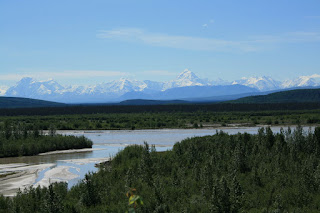
Our first majestic glimpse was that of the Alaska range that started coming into view pretty much as soon as we were leaving Fairbanks. As we crossed Delta Junction and the range came closer the views kept getting better.... Plus there were long stretches of the highway when we couldn't see a car for miles around us.
The Alaska Range along Denali Highway
There are portions where the highway runs parallel to the Alaskan Oil Pipeline. S had stopped to take pictures of the pipeline when he got talking to someone travelling in the other direction. This person told him - "Summit Lake is looking beautiful today". As we drove on we came upon this pristine blue lake clearly reflecting the snowcovered mountains around. This was definitely the high point of our drive.
Summit Lake
A larger part of the day had now been spent in the car. We were getting tired and were not stopping as much as we were in the beginning of the drive. But as we approached Glenallen, the Wrangell Mountains started coming into view - Mt. Sanford, Mt. Wrangell and Mt. Drum. The excitement came rushing back.
The Wrangell Mountains

Mt. Blackburn
Mt. Wrangell
This post is getting long...moreover I am getting sleepy. Rest of Richardson Highway in the next post.


Comments
I like the idea of your posting...
Good Luck
http://www.trekearth.com/gallery/South_America/Argentina/South/Santa_Cruz/El_Calafate/
PS: Sorry to bother you here with this, but I'm trying to find the current e-mail address of Christopher Wingert, with whom I believe you worked with in Qualcomm. Any ideas?.
If you can, please write to me fcassia at gmail dot com
Thanks,
FC